Trip Report: Atlanta to the Georgia Guidestones
In August I went on a bike excursion from Atlanta to the Georgia Guidestones and back. I’ve known about them for a while, and have been curious to go see them, but never enough to drive the three or so hours it would be round trip. I never pass through that neck of the woods either, so I’ve never had a reason to stop while passing through. Last week, management at work announced a surprise day off kind of last minute. I had nothing planned, so I decided to build a route and put this unexpected three-day weekend to use. I used a combo of Strava and Ride With GPS to build the route. Ride With GPS’ route builder is far better. It has more powerful tools like reversing a segment. Strava’s wealth of user data allows it to direct you along the most popular paths, though. It’s a great way to jaunt down pleasant country roads instead of miles of harrowing divided highways. I used Strava to connect three waypoints: my house, downtown Athens, and the Guidestones. I imported it into Ride With GPS to make some tweaks. I cut unnecessary diversions (popular segments aren’t always the shortest), opted for a few gravel farm roads, and cut through a couple parks instead bypassing them.
My plan was to stop in Athens (75 miles) for late lunch. I’d continue to the Guidestones (116 miles), take a picture, and then push the last 10 or so miles to the South Carolina border (125 miles). There I’d camp along the Savannah river. In the morning, I’d wake up and do the same thing in reverse.

I suited up my everything-bike, the Surly Straggler 650b edition. I have a Swift Industries Paloma bar bag that can hold most everything I need during the ride: some trail mix, my phone, chargers, sunglasses, sunscreen, wallet, electrolytes, and other miscellany. I stuffed my summer sleep sack and tent into my custom Spindle tail bag, and bungied the tent poles under my top tube. I decided I was going to try recording the entire trip on my phone using Ride With GPS instead of relying on my Garmin. I have the cheapest Garmin money can buy (Edge 200) and its turn-by-turn directions are… lacking. The battery also tends to max out at around the century mark. My SON 28 dynamo hub, connected to a Sinewave USB charger on my stem, can keep an iPhone charged if you’re riding about 10+ MPH. Instead of juggling several devices, I figured I’d just keep the my phone on the dynamo. Of course, I charged my headlight and taillight the night before. They’re both good for a century and I can charge them on the dynamo for day two.
Day One
I got up before dawn to have my coffee, put on sunscreen, and ate a couple of bananas. In retrospect, I should have had more for breakfast, but I’m not really a breakfast person. My thought is always to get started and then have breakfast a little later when my stomach is awake. Sadly, much of Georgia is a barren, empty patch of dirt with no breakfast along the way. I got on the road at 07:30. I live in Brookhaven, so I headed pretty much due-east for the first 15 miles. There isn’t much to say about getting outside the Metro Atlanta area in this direction–it’s a snooze fest. I drafted off of a couple roadies in Tucker, out for their morning training rides. The roads are pretty busy and there’s not much to see. I just try to stay alert to passing cars and use this time to let my mind wander. I probably do some of my best thinking, ruminating, and reminiscing during rides like this.
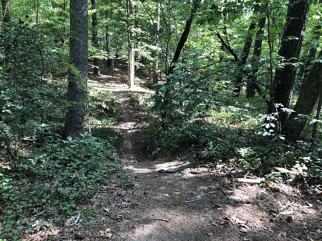
I made it to Tribble Mill Park, mile 30, in about two and a half hours. The cool morning was starting to give way to sweltering Georgia heat. It wasn’t “hot” yet by Georgian standards, but it was getting there. At Tribble Mill, I had routed through some paths instead of staying on the roads. Little did I know, the paths I chose were mountain bike single track. Luckily, it was nothing too technical and I only had to walk a couple spots for fear that getting rad would bounce everything out of my bar bag. Despite my precautions, I did bounce my phone out and had to backtrack to search for it while yelling “hey Siri!” like moron. I ran into a mountain biker who asked if I was looking for something. Thankfully, he had picked it up. I guess that means I’m technically cheating on Strava because a few tenths of a mile are that guy’s ride.
After another two hours, I made my first rest stop at mile 48 in Bethlehem, GA. This stop wasn’t actually on my route. My 2017 tour in Taiwan trained me to be cavalier about supply stops because it seems like you’re never more than a few kilometers from the next 7-Eleven. I emptied my first bottle, and had a few sips left in my other, so I stopped and used Google Maps to find the closest station. It seemed like my plan to just run into one eventually was not going to work. Bethlehem is actually a really cute little town with a lot to see. I’m just kidding, there’s absolutely nothing there. Refill your water bottle and move along.
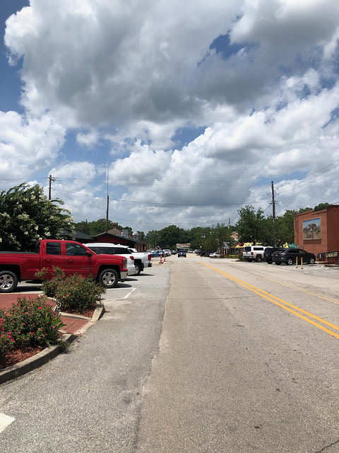
Then next 10ish miles to Statham were pretty chill. There are only two turns, and it’s all bucolic farm scenerie, and no major climbs. Just gentle rolling hills through Georgia’s pasture land. I can dig that kind of riding. If I had to deduct points, I’d say it lacks a little tree cover, and I happened to be passing through during the intense noon heat. Statham itself is actually a cute little town. If I had any sense I would have stopped for lunch. Instead, I figured I’d push onward since I was only about 15 miles from Athens.
There is a more direct route that passes through Bogart, but I chose to take smaller roads past Bear Creek Reservoir almost to Attica and then. I thought it’d be nice to ride past the reservoir and wanted to avoid traffic. Turns out, this segment of the trip was the long dark night of my soul. Or I wish it had been dark and night, because it was long, hot, and exhausting. The countryside is not pretty, and it felt very desolate and lonely for a while. Some places in Georgia have a knack for giving me that feeling. It was peak afternoon heat, and I started having trouble keeping my pace above 10 MPH. When I finally got to a gas station on the outskirts of town I was starting to bonk. If you’ve ever had that feeling, you know what I mean. When I got off the bike, I was having trouble keeping my eyes open. I had the overwhelming desire to sit down immediately and just sort of crash for a minute. I drank a Gatorade and a bottle of water and half-dozed for about 30 minutes before I finished riding into Athens (mile 75).
During the last few miles into town I started thinking to myself that I ought to call my friend Jonathan and ask if I can pitch my tent in his yard. I decided I would give that plan B some serious consideration once I had some food in my belly. I found some BBQ downtown and sat in the shade to refuel. I took almost an hour to eat and rest. Around 15:00 I expected the heat to start receding at any time, and I was feeling better about the remaining 42 miles I had to get to the Guidestones. I don’t know if any other cyclists do this, but I have this great/terrible way to encourage myself. I look at the next cherry-picked destination about 40 miles away and tell myself something like “40 miles is nothing! That’s like one Faster Mustache ride. You used to do those at 6pm after all day at work. You’ve got plenty of time!” completely disregarding the 75 miles already behind me.
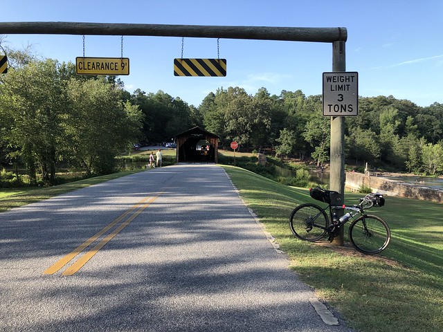
Since I had been thinking about calling it quits before leaving Athens, I promised myself I would watch my pace and take a break within 10 miles. I stopped at the Golden Pantry in Winterville six miles later. The heat was still sweltering, so I rested about 15 minutes before moving on. Northeast of Winterville, the countryside is beautiful. I’ve passed through these parts during the Athens Twilight Gambler ride. I always enjoy the rolling hills dotted with barns and trees. I made it to the Watson Mill covered bridge (mile 95) around 18:30. A couple miles later as I was rolling up to a stretch of road that runs along the train tracks in Carlton, I pulled out my phone to snap a picture. Just as I took it, a dog came running out of someone’s yard and chased me for several yards as I awkwardly tried to sprint while not dropping my phone.
The heat finally broke and I could push a little faster. The ten miles from Carlton to Dewey Rose were pretty uneventful. I hit the century mark at the Tiny Town Minit Mart on River Road. I took a pit stop here for a few minutes to refill my water and grab an extra bottle to throw in my bar bag to make sure I had water overnight. It was 19:00 and I at this point I had decided I wouldn’t make it to the campsite at the state line. Right past Dewey Rose I hit the gravel farm roads I had opted for. I got chased by another evil doggo, but this time I was able to dig deeper and get away without much difficulty. Corn on my left and soy on my right. The stars were out, the moon was almost full, and flocks of swifts swirled overhead as I passed through the fields.

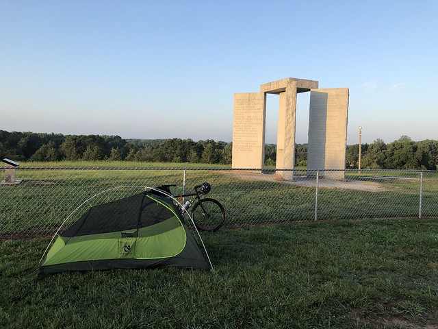
I emerged from the gravel roads and could see the guidestones illuminated on the hilltop ahead. The odometer rolled over to 116 as I pulled up to them at 21:00. A family was walking around looking at the different languages carved into the faces of the monoliths. I had decided on my way through the farm roads that I definitely was not going to push onwards to the SC line to camp. I took a few pictures, set up my tent in the parking area, and then passed out cold.

Day Two
The return trip promised to be a little harder. I had just ridden the 116 miles the day before, I slept rough without a sleeping pad, and the return route was at a slightly higher average grade. I learned my lesson the day before about hammering 50 miles before taking my first break and committed to take my first break within 20 miles. I also decided I was going take it easy during mid day. If that meant riding 5 MPH or taking a long nap during peak heat, and I couldn’t make it home until midnight, so be it. I broke down my tent, packed up and pulled onto the road around 07:45.
The fields I passed through were far less magical during the day than they were under starlight and a full moon with the swifts. I was nervous about my second encounter with the evil doggo because I was sure he sat up all night thinking about me like I did about him. Luckily my fears were unfounded because doggo’s gate was shut and his owner waved at me as I cruised past. I took my first break about an hour and half later at the Tiny Town Minit Mart (mile 16). It was pretty warm already and I had worked up an appetite so I grabbed some slimjims and cheese, topped off my water and got back to it.
As I approached the place where the first godless hellhound of the day before had snapped at my heels I made sure to build up speed. I kept my effort at 80% so I could sprint past him when he came charging. Like evil doggo number two, this one was also unwilling to violate Sabbath and I passed without incident. I went back through the covered bridge and traversed the pretty farmland northeast of Athens. I was starting to feel pretty burned up somewhere around the 30-mile mark and had to visualize the Golden Pantry in Winterville to keep myself going. A few miles before I got there I stopped to eat some trailmix and drink some water (of which I was almost out). I noticed that I was at an animal sanctuary. The pig looked pretty tasty, but sadly we’ll probably never know. I spent a few minute talking to the him and the llama, but they were more interested in their veggie scraps so I kept going before too long.

When the Golden Pantry (mile 35) came into view it was like an oasis in the Sahara. I donned a mask and loaded my arms up with absolute garbage to eat. Have you ever wondered who eats the pork rinds, pickled “Tijuana Mama” sausages, and Muscle Milk? It’s me. This store does have some delicious pickle chips in a bag that I haven’t seen elsewhere, so I ate two bags of them and drank all the pickle juice. After my trash feast, I took a nap for about 30 minutes. It only took about 25 minutes to ride the rest of the way into Athens, but when I got there I was still hungry and it was still hot so I ordered a poke bowl. Still not feeling the heat, I took my time, enjoyed second lunch, and cooled off in the shade. On my way out of town on the west side, I stopped for another short break and got an iced coffee.
I think I was psychically preparing to bridge the wasteland between Athens and Statham by procrastinating. I didn’t get back on the road until 15:30 and mind you, I still had at least 70 miles to ride. This segment proved to be the worst again. If I ever do this trip again, I’m modifying it to pass through bogart or something. I hate this spot. I rolled into Statham (mile 60) around 17:00. I was feeling hot and worn out, so I hung out at a gas station for about 30 minutes and munched on an ice cream bar and a Five Hour Energy. During the last 20 miles or so, the ride had pivoted from adventure to stress about getting home before midnight, the batteries in my lights and phones die, or my legs die. Thankfully the heat had started to recede. I texted some folks to let them know my status since it was getting late. My friend Kartapreet kindly reminded me that I could pitch my tent and ride the rest in the morning, and that UberXL is always an option.

I got back on the road and planned hammer as long as I could, half anticipating another rest at Tribble Mill. The cooler temperature and the Five Hour Energy had me feeling better. I could maintain a slightly better pace and tried to get some charge on my phone during the downhills. It’s a little annoying, but if you’re hovering right around 9-10 MPH, it will actually kill the battery because it frequently starts and stops charging. I would disconnect it before an ascent and when I got to the top I’d plug it back in. I was able to keep the it around 30-40% charged for the rest of the trip. I passed right through Bethlehem like there was nothing there (because there isn’t) and made it to Tribble Mill around 20:00. The sun was setting and it was finally cool, or as cool as it gets down here in August. My Achilles tendon had been bothering me for a while–the whole day really–but now it was actually becoming a problem. I couldn’t get full flexion of my ankle, and it made this weird sound/feeling like rubbing rubber against rubber when I tried to. My ankle was starting to swell a little. I took 25 minutes to stretch it out, eat the rest of my trail mix, use the bathroom, and refill my water.
I still had about 30 miles to get home, or, you know, just two consecutive WNJACS rides like I used to start at 20:30 all the time. Piece of cake. I was feeling much diminished compared to when I pull out of Statham and I longed for the burst of vigor that the Five Hour Energy had given me. I pulled over at a Wallgreens in Grayson to get myself another one and a bottle of Gatorade. When I came back out, my taillight refused to turn back on. I threw it on the dynamo and clipped it to the outside of my left handlebar. It can charge while in use, and I can keep it charged indefinitely as long as I maintain about 6 MPH. When I got up to speed, the charging indicator didn’t light up. I tried to turn the light on and it wouldn’t. I’m still not sure what happened, but I think that this must be yet another light that got fried during a rainstorm. I passed through several light showers and one downpour earlier in the day. I’m sure my buddy Chris would be thrilled to see this happen again. At this point I had bike-brain and my judgement was severely compromised. I took my headlight and attached it to the outside of my handlebars where I could swivel it back and forth. It has these yellow safety lights on the side so I pointed the headlight onto the road to my left hoping that anyone would be able to pick up the yellow dot or see the illuminated patch of road and slow down. After a few trucks passed me blasting their horns I thought to myself “This is crazy, Zac! Do something rational!” so I hopped the curb and started plowing down the sidewalk, cutting into the road where no sidewalk was available.
After about 8 harrowing miles of poorly lit Gwinnett County roads I made it to Five Forks (mile 95) near Lilburn. I decided to investigate whether I could find a USB charger or some kind of emergency light. QuickTrip had nothing, so I rode across the street to CVS. They were closed. I looked at the hours on their door, which said they close at 10. My phone confirmed that it was indeed past 22:00. For a moment my brain churned through how to make this work like Mac and Dennis trying to figure out how they still have a business with no customers, inventory, or money, before coming to my senses and deciding I had to call it and take an UberXL home. 30 minutes later I was safe at home and the whole thing was a nightmare that was finally over.
And thus concludes one of my top worst ideas. I won’t ever try to ride two centuries, back-to-back, without a rest day, alone, during the height of Georgia’s summer again. This trip could be a lot more fun with some friends, but pace management is important if you want to get there at a reasonable time. I’m not sure about the validity of pitching a tent at the Guidestones themselves. No one bothered me, but that doesn’t mean it’s okay. I was just too exhausted to make it the rest of the way to camp at Georgia River Campground like I had planned. Spending a rest day there and getting two nights of sleep before slogging back would make this trip more fun, but you’d have to push a full 125 miles to get to camp. Not impossible, but it might be tricky since the campsite doesn’t take reservations. I’ll be making some tweaks to the route to make sure it hits a watering hole every 10-20 miles and to avoid the stretch Statham and Athens. If I ever make this trip again, it will probably be a long time from now.